
Through and Through: One day through-hike from the coast to the Matilija Wilderness
Straddling the coastal spine of the Transverse Range, I hiked (and sometimes ran) the sandstone sea serpent that rises and falls east to west all the way from the idyllic Gaviota Coast to the stunningly breathtaking Matilija Wilderness, a stone’s throw away from Carpinteria.
The chaparral-choked Santa Ynez Mountains are one of the main gateways with several front-country trails leading to the backcountry wilds of the Los Padres National Forest, and the Cenozoic range is one of just a few in the U.S. trending east-west. One of the most unique aspects of living close to the national forest is standing on its prominent coastal spine, gazing out across the Santa Barbara Channel to the Channel Islands National Park, the isles also part of the Transverse Ranges.

With the 7.9-mile Franklin Trail reestablished following fires and mudslides in 2018, the winding trail is the newest route into the National Forest. Ascending and weaving from the Carpinteria Valley to the narrow ridge of the Santa Ynez Mountains, it’s only natural to connect the dots, run the spine of the range and descend alongside all the soothing, gurgling tributaries that feed the Matilija Wilderness.
Darkness Calms

There’s something said for hiking on a cool winter’s night. There are no bugs to speak of. It’s refreshing. T-shirt, shorts, beanie, trail shoes, the head is warm, but the cool air feels just right and enhanced my pace up the Franklin Trail.
With my headlamp burning bright, it’s one foot in front of the other, and for a few hours the distance was forgotten. Lost was how far it was or how steep the route got in The Franklin’s upper reaches. Visibility carried only as far as the brightest beam from my headlamp. Drifting off into a meditative state was easily accomplished and settling in for the first several miles before sunup was simple. Of course, all that went out the window once the initial, significant rustle of coastal sage scrub occurred, thus heightening my senses. Megafauna or just another spotted towhee sounding larger than it really was?
Timed on a setting full moon and greeted by a new dawn, I stopped and gazed in 360 degrees. Heaven would have to wait. As orange and pinkish hues swept across the horizon, it had to be one of the best panoramas on the entire West Coast. A light frost crusted over the dense chaparral and a wisp of northeast wind wafted down the steep, narrow canyons to the Carpinteria Valley below. The shimmering Santa Barbara Channel was flawless, and those ever-present isles continue to beckon.

Once on top of the ridgeline though, there’s a magnetic pull toward rugged backcountry bliss. As the spine continued to gradually veer eastward, the ocean became a little more distant, but with the sun rising over the channel, a clear day can mean striking visuals of land and sea. It’s not every day, even from 4,000 feet above, that one can see San Nicholas and Santa Barbara Islands, the canyons of the Northern Channel Islands, Point Mugu, Sandstone Peak, the high summit of the Santa Monica Mountains, the daunting Topa Topa Mountains and even the Santa Ynez Valley smothered in Tule fog. Those were the possibilities revealed while standing atop the rambling spine of the Santa Ynez Mountains.
Backcountry Transition
My map is old. It’s over 20 years old. It’s not tear-proof. It’s not tatter-proof and some things have changed out here in the backcountry or remain unmaintained over the last two plus decades.
Having said that, I couldn’t locate the Monte Arido Trail, the connector between the Santa Ynez Mountains and the Murietta Divide. At 4,707 feet, Divide Peak is four miles west of the Franklin Trail connector resembling a ragged rib rolling toward the coast. Once at Divide Peak the OHV route bends to the northeast, then east climbing and rolling toward the Matilija Wilderness.

Certain features came into play walking eastward. The vein of the upper Santa Ynez River snaked west from shimmering Jamison Lake. East of the lake, Juncal Canyon converged with Murietta Divide, Rincon Creek and east of the boulder-strewn creeks and above was Old Man Mountain.
No Monte Arido, no problem. Locating what appeared to be an old bulldozed track down a steep, rolling ridge that maybe lead to Jamison Lake, I took it. A steep descent into a loose, rocky gully leading to the bulldozed route quickly led to the sounds of a gurgling creek. Veering off the bulldozed route onto a narrow ridge, I thrashed through remnants of burned out Thomas Fire snags and low-lying new growth, slipping and sliding in thick, soggy earth by recent rains and snow.
Converging with the Murietta Divide was a maze of oak tree groves, willows, boulders and creeks before reaching the road leading up Murietta Canyon. Every now and then fallen trees covered the road. Recent rains left soft, compacted mud revealing a myriad of defined wildlife spoor; black bears, bobcats, mule deer, gray foxes and striped skunks, heaps of activity relying on a nearby water source.
The Good Luck Bug
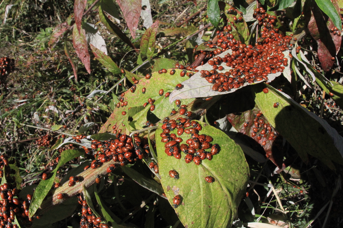
However, while enjoying a burrito break, one of the smallest yet most popular residents of the forest quickly cluttered my map. A few dozen ladybugs soon led me to a busy colony of thousands along Murietta Canyon. They were enjoying the soggy earth, clustered on all leaves and branches within the near vicinity. Their black spots stood out against their bright red wings.

In many cultures they’re considered good luck. There are about 5,000 species of ladybug in the world. The most common, the most notable is the seven-spotted ladybug. They use their black spots and a secretion oozing from their joints as deterrents against potential predators. Plenty of those lurking in the dense chaparral.
Beyond the ladybugs, I rounded the last bend in the muddy road and the Matilija Wilderness eventually opened before me. Fall colors still clung to the North Fork and the rhythm of the creeks led me to my shuttle back to Carpinteria.
You might also be interested in...


