
Earth’s Past Climates
Most people know that Earth’s climate has changed periodically over the last couple of million years. Ice ages have come and gone along with wetter and drier periods in the more temperate zones. Picture two miles of ice on top of Canada and the northern United States, glaciers snaking down from the Sierra Nevada, lakes dotting the Mojave Desert including one 600 feet deep in Death Valley, and similar conditions in the Sahara.
People were around during this period and had to adapt to these changes, which occurred about every 50,000 years or so. The last ice age wound down about 15,000 years ago and it’s no coincidence that during the stabler climate since then, agriculture was developed, and cities grew. As the deserts dried out over the last 10,000 years, people had to move to survive; it’s during this time that the ancient Egyptians migrated toward the Nile River.
Geologists early on in Europe and later in North America recognized a repeating pattern of glacier deposits buried under younger sediments. Because it was so difficult to get good dates for the boulders that make up the glacial moraines and other material the glaciers deposited, geologists just gave these various signs of old ice ages names and assigned them a relative-age order.
So, in Europe we have the youngest deposits named Riss and Würm and older ones named Günz and Mindel, all named after rivers related to the glacier deposits. In North America, it was unknown if our ice ages matched up with Europe’s, so we gave them our own names, like Wisconsin for the youngest and Illinoian and Sangamon for older ones. The Sierra Nevada got its own chronology from Sherwin and Tahoe to the youngest, Tioga.
Finally, in 1930, a Serbian mathematician named Milutin Milankovitch published an analysis of changes in Earth’s orbit that he projected back in time and predicted that they could explain the cycles of the ice ages. These so-called Milankovitch cycles fall into 3 classes: 1) Eccentricity, which is a measure of how circular or oval Earth’s orbit is, which varies on about a 100,000-year cycle; 2) Obliquity, the tilt of Earth’s axis, which varies between 22 and 24 degrees every 41,000 years; and 3) Precession, which is the wobble of a top as it spins, which tilts the Earth toward and away from the Sun over about 20,000 years.
Right now, Earth’s orbit is circular and our Northern Hemisphere tilts toward the sun in the northern summer, but when that changes, more snow and ice can start accumulating at northern latitudes, eventually triggering an ice age.
It took a while to verify Milankovitch’s claims as we needed good dates of the ice ages. The first dates were developed on coral reefs in Papua New Guinea where sea-level drops caused by all that water being locked up on land in ice sheets stranded the corals. When the ice melted, the corals grew again. Tectonic forces continuously lifted the island so that a rhythmic series of coral steps were preserved. Small amounts of uranium trapped in the corals allowed them to be dated by its radioactive decay, as discussed in my last article.
More recently, deep-sea cores have been obtained in ocean basins all over the world that clearly depict the cycles of ice ages and interglacial times. These have also allowed us to determine how the timing and intensity of the ice ages have varied all over the globe. Dating of the layers in the cores uses various radioactive isotopes, but inference of the temperature of the ocean water at those distant times uses other, stable isotopes.
It turns out that oxygen has a natural, stable (non-radioactive) isotope with two extra neutrons, called O18. In the 1950s, scientists found that cold water evaporates less with the heavier O18 so that ocean water during the ice ages had heavier O18. That was then trapped in the shells of plankton and other animals that fell to the sea floor and became the sediments scientists cored. Thus, we could produce a nice graph of age versus temperature from the deep-sea core. Ice cores on the polar caps in Antarctica and Greenland have produced the same information, though in their case, the water has more of the lighter O16 that evaporated from the cold oceans. An additional problem on the ice caps, though, is that there’s no material to date, so the ages must be estimated by other means.
Now we know that there were strong ice ages about 400,000, 320,000, 120,000, and 15,000 years ago and weaker ones around 200,000 and 60,000 years ago. We’ve also seen how Europe and North America were pretty much in sync, but Northern Africa, including the Sahara was offset in time and followed changes in the Monsoons to the east.
It turns out Mars has also gone through ice ages of its own. Scientists studying small changes in Mars’ orbit have been able to project changes back a few million years there, too. Currently, Mars’ axis tilts about the same as Earth’s (25 degrees) and it goes through seasonal cycles like Earth — you can see its polar caps expanding and contracting with the seasons. However, its obliquity (the tilt of its axis) has ranged a lot more than Earth’s — up to about 35 degrees, meaning almost the whole planet was engulfed in ice at various times. When this was discovered, it answered a lot of questions about landforms near Mars’ equator that looked like they had formed under ice. They had and were preserved after the ice retreated.
Less is known about past climates of our other nearby planetary neighbor, Venus. Its present atmosphere is mostly carbon dioxide and is very thick; pressure at the surface is about 90 times that of Earth. However, there is some evidence that in its distant past, Venus may have had liquid water on its surface. Exploration of Venus will have a renaissance soon as three spacecraft were just approved to learn more about Venus’ past and present — two from NASA and one from the European Space Agency. NASA’s DAVINCI+ will concentrate on the atmosphere where there is still evidence of a watery past. VERITAS will map the surface and search modern and ancient crust for signs of current and ancient activity. ESA’s EnVision will complement NASA’s studies of atmosphere, surface, and subsurface. The three should launch about 2030.
A third body in our solar system has recently been discovered to have a “climate”: Saturn’s moon Titan has an atmosphere of nitrogen and some methane that’s about 1.5 times as thick as Earth’s and, due to its distance from the Sun, the temperature is just right for methane to evaporate, condense, and flow like water in rivers and lakes on its surface. We still don’t know enough about how conditions may have changed over time at that remote location, but there is some indication that the very slow changes in Saturn’s orbit may have led to climate changes for Titan. More detailed investigations would need to be done to learn if Titan ever had an ice age. To help answer those questions, Dragonfly is a new NASA/Johns Hopkins University mission (https://dragonfly.jhuapl.edu) that will land a helicopter on Titan in 2027 to investigate its atmosphere and surface.
Meanwhile, we can see the effects of the ice ages in our local terrain. It turns out tectonic forces have conveniently caused the Central Coast to rise continuously over the past million years or so, while sea level has dropped and risen during the ice ages and interglacial intervals. The uplift was slow enough that the ocean was able to carve beach platforms, which then became terraces as the land continued to rise.
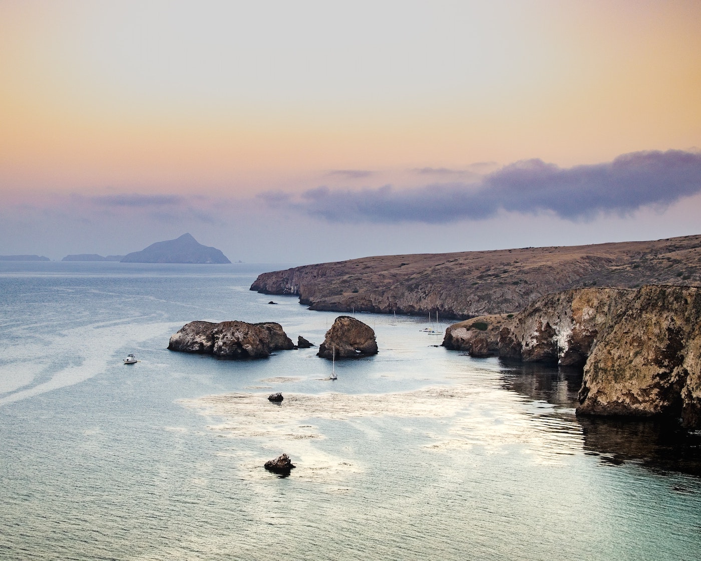
Nice profiles showing off flights of wave-cut terraces can be seen at Gaviota State Park and El Capitán State Beach as well as on the Channel Islands. Speaking of the Channel Islands, it turns out that sea level was so low during the last major ice age, that San Miguel, Santa Rosa, Santa Cruz, and Anacapa islands were connected, forming what has been named Santa Rosae Island, which was only about five miles from the mainland. Humans apparently took advantage of that and settled the island during that recent low stand. As the most recent ice age warmed up and the ice sheets melted, sea level rose by about 300 feet and the islands took their current form.
Human evolution and movements were certainly shaped by climate changes over the past million years or so. As humans spread out from northeast Africa, they were assisted or stymied by the recurring ice ages and concurrent sea-level changes. One of the more interesting findings is that humans may have migrated to North America via a land bridge spanning the Bering Strait between Russia and Alaska during the last ice age. There is still some controversy over this and an alternative has been proposed where these early North Americans could have instead made their way by sea, following what has been dubbed the “kelp highway” just offshore.
Archaeologists are now using scuba and other high-tech gear to search for signs of early humans migrating along the now-drowned shelves that would have been coastlines during the ice ages, including around the Channel Islands. Something to think about when looking across the channel or anchored at the islands is that this could have been one of the earliest crossroads of North America.


