
Redistricting Will Impact Montecito
The Citizens Independent Redistricting Commission, which is comprised of 11 commissioners representing all five supervisorial districts in Santa Barbara County, is seeking input from the public regarding redrawing our district map, which will be in place for the next 10 years.
“We’ve been working on this for over a year, and we are now at the point where we really need the public to submit their ideas of what they want the new maps to look like,” said Montecito resident and Commissioner Cheryl Trosky, who, along with Mission Canyon resident Karen Twibell, is representing the First District.
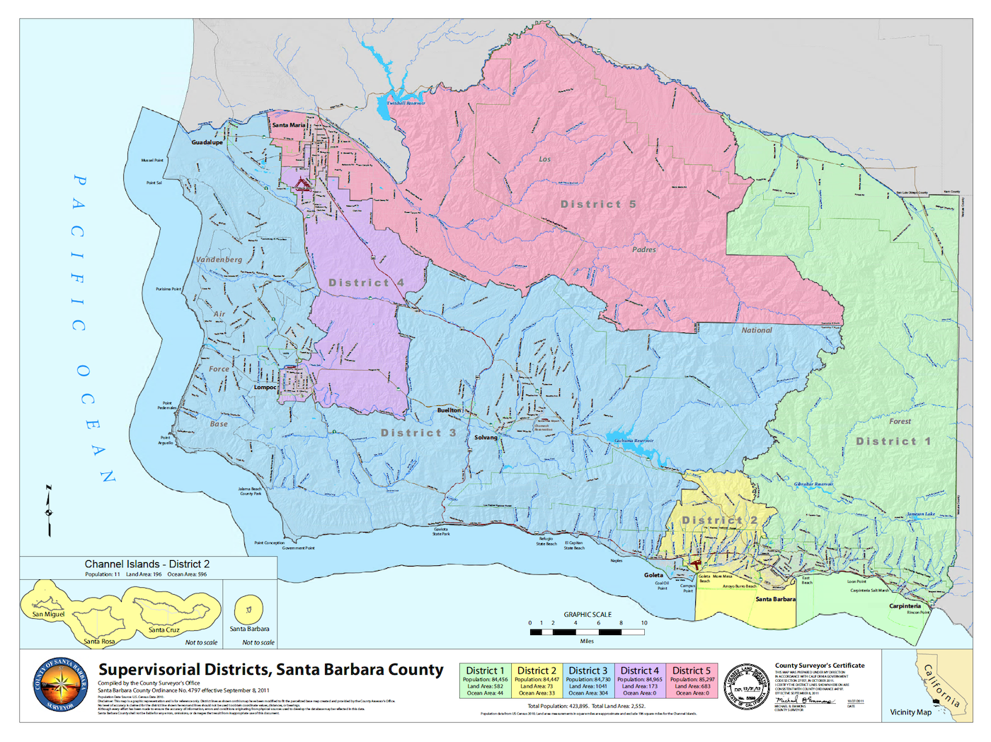
Every 10 years, following the national census, election lines are redrawn, which changes district constituencies. The new election lines determine which community members are placed in each supervisorial district, and voters within each district will elect one of their own as a County Supervisor. Currently, the First District comprises Carpinteria, Summerland, Montecito, East Beach, downtown Santa Barbara, the Riviera, the Upper East, Mission Canyon, and San Roque in the South County, as well as New Cuyama in the North County.
“Every ten years we have the census, and every ten years the population shifts,” Trosky explained during an interview earlier this week.
Prior to this redistricting, the maps were drawn by County supervisors themselves, but Measure G, which passed in 2018, authorized the Board of Supervisors to create an independent commission to adjust the boundaries of the supervisorial districts. The new districts should all have roughly the same amount of people; this year each district should have 89,300 people – give or take a 10% total deviation – based on census data showing a total population of 443,000. Currently District 1 has 83,500 people, so part of this year’s redistricting task is to add more people to the district.
“We want to make sure, that as a community, people feel like they are represented in their districts,” Trosky said.
Districts should be cohesive, contiguous, compact, and comprised of people that are like-minded, so factors such as shopping areas, school districts, religious centers, cultural demographics, racial and ethnic compositions, and economic and social interests are of utmost importance. Other considerations include HOAs, and service boundaries such as water, sewer, and fire protection areas.
The Citizens Independent Redistricting Commission has a dedicated website to keep residents informed and to gather input in various ways. People can draw their own ideal map, either a hard copy or through a simple online program (tip: take the quick tutorial and zoom in closely to see every street name). They can also send an email describing their ideal map boundaries, and what makes an ideal area to be reflected within a district.
Members of the public are also encouraged to subscribe to the Commission’s emails, to remain in the know of upcoming meetings and deadlines. The next deadline is October 18, which is the deadline for the public to submit their own ideas for the maps. There will be multiple opportunities to help finetune three to five “focus” maps, at seven different meetings in October and November, which will take place in various locations throughout the county. A proposed final map will be posted December 5, and the public has three days to look at the proposed map and provide input before its adoption December 15.
“At this juncture, I’m not really sure how the map is going to look,” Trosky said, adding that it’s likely that District 3 (Lompoc, Vandenberg, Guadalupe), District 4 (parts of Lompoc and Santa Maria), and District 5 (part of Santa Maria) are going to change quite a bit.
“We’ve heard from those communities that it makes more sense for Santa Maria and Guadalupe to be in the same district,” she said. District 3, which comprises the Santa Ynez Valley and Isla Vista, may also change.
“We’ve heard from IV constituents that it makes more sense for them to be considered with Goleta or Santa Barbara rather than the Valley,” she explained. “In District 1, it might make sense to not include New Cuyama.”
It’s also probable that Santa Barbara will continue to be split among two Districts (Districts 1 and 2), as the population is too large for just one district.
The Commission wants your participation, as of press time only eight people had submitted draft maps.
“We really want to know what people want to see. It will impact our Board of Supervisors for the next 10 years,” Trosky said.
To participate, visit www.drawsant abarbaracounty.org. To draft a map online, click on the Draw a Map tab and click on DistrictR. Instructions can be found there. If you have questions, or want to email the Commission, email: redistricting@countyofsb.org.


