
Latest on Randall Road Debris Basin
On Monday, November 4, the County of Santa Barbara hosted a design workshop to present preliminary sketches of the debris basin slated for Randall Road, as well as give an update on the progress of the quick-moving project.
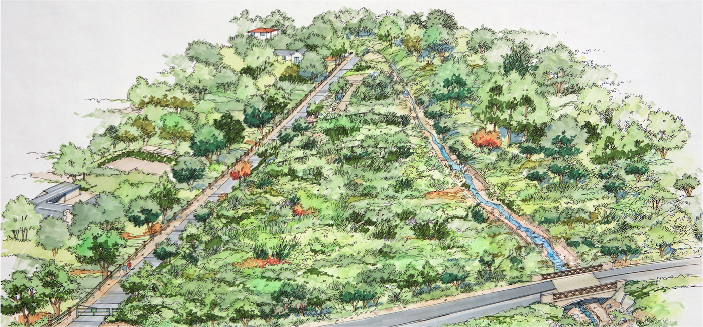
The debris basin project, which includes the acquisition of seven parcels on Randall Road and one on East Valley Road, will offer improved debris catchment from San Ysidro Creek. Preliminary design concepts for the project include excavation to widen and deepen the eight acres of property adjacent to the creek channel, upstream of the Highway 192 bridge/culvert, thus creating a catchment area to collect debris during storms and/or emergency events. The design of the basin will mimic the sedimentation patterns following the 1/9 debris flow, with the majority of the basin located on the west side of the creek and a small portion located on the east side of the creek. The eight-acre basin would be five to eight feet deep, be screened with trees and shrubbery, and cleared out after storms, said design consultant on the project, Lesley Brooks.
The location of the proposed debris basin was heavily damaged during the 1/9 debris flow, with the majority of the private properties on Randall Road severely impacted with mud and debris. County Flood Control Engineering Manager Jon Frye explained that the 1/9 disaster was history repeating itself; a similar mudflow occurred after the Coyote Fire in 1964. The debris basin would serve to reduce the downstream impacts of debris deposition, according to the County’s Deputy Director of Water Resources, Tom Fayram, who added that even with the Randall Road debris basin, the disaster on January 9, 2018 would not have been completely avoided. “With the enormity of 1/9, we still would have had significant flow, but it certainly would have helped. We would have stopped a lot of rocks at this location that wouldn’t have gone downstream,” he said.
The site has several constraints, including easements, existing utilities, requirements for fish passage, and the nearby bridge at East Valley Road. Additional benefits of the basin include providing open space, increasing groundwater infiltration, and adding hiking access. The trail adjacent to Randall Road would be offered to Montecito Trails Foundation and the County Parks Department, with potential for a future connection to San Ysidro Trail.
The County is utilizing a limited window of opportunity to design and permit the basin, which First District Supervisor Das Williams said would offer long lasting benefits to Montecito. The first step is property acquisition (currently in progress), followed by environmental review and permitting, and then design and construction. The project is projected to cost $20M, not including maintenance on the basin. Funding options include FEMA grants, private funding sources, and increased Flood Control assessments, which are being investigated. Several agencies are currently coordinating for the permitting process, including the Army Corps of Engineers, California Water Boards, NOAA’s National Marine Fisheries Service, FEMA, CA Department of Fish & Wildlife, and the County. The County is aiming to build the project in two years; a typical project of this type usually requires 5-10 years. A draft environmental document on the project is expected in the Spring/Summer of 2020, with a final EIR expected in the Fall/Winter of next year. Design will take place concurrently, as the County has already hired a design consultant to oversee the project. It is anticipated that permits will be pulled by the end of 2020, with construction beginning Summer of 2021, and completed by Fall of 2021.
Curtis Skene, whose home sits below Randall Road and was destroyed in the 1/9 debris flow, spoke at the meeting, thanking the property owners who have agreed to sell their properties to the County in order to build the basin. Skene is credited with rallying the homeowners and working with the County to push the project forward. He announced that he has set up a non-profit organization in order to work on looking at other creeks in Montecito, in hopes of mitigating another massive debris flow. “I cannot say enough about the folks in the County, you all have no idea how hard these people work day in and day out. You all should feel comforted,” Skene said.
“Normally when we start a project like this it’s very incremental,” Fayram said. “What you are seeing here tonight is that we are all in. We do not have FEMA approval for the money, yet we’ve already hired a design consultant, we’ve got the EIR consultant, and we are applying for permits.” He went on to say: “We have gone all in. You have the commitment from us to do everything in our power to get this done. This will be one of the larger basins in our inventory.”
For more information about the basin, visit www.countyofsb.org/pwd/floodcontrol.sbc.


