
Board of Supervisors Approves FEMA Map
On Tuesday, June 19, the Santa Barbara County Board of Supervisors unanimously voted to adopt the use of the new FEMA Interim Recovery Map, which was released last week and was the basis of our cover story (MJ #24/24). “This map is not gospel, I don’t think it’s perfect,” said First District supervisor Das Williams. “It is a model and a more useful tool than what we have.”
County Water Resources deputy director Tom Fayram presented the map and associated findings to the Board, strongly urging approval of the map. “This is by far a superior product than anything we’ve ever had. It utilizes techniques and data that is far superior, and I strongly urge you to approve this map – it’s the best thing we can do for our community.”
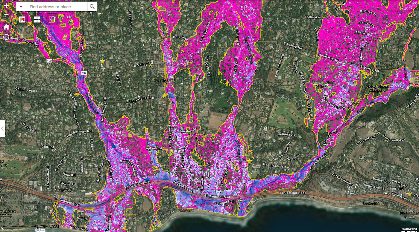
The map shows high-hazard flood areas within yellow borderlines; properties that are within the yellow borders that are not in the blue overlay can expect to flood 0-6 inches during a 100-year flood. Shaded areas on the map reflect a greater risk of flooding; the lightest blue indicates 6 inches to 1 foot of flooding, while the darkest shade of blue indicates the potential to flood more than 10 feet. Medium shades of blue have varying degrees of flood risk, from 12 inches to 5 feet. In order to adhere to local Flood Control ordinances, homeowners will be required to rebuild their finished floor 2 feet above the base flood elevation indicated on their property.
Fayram explained that while the map is not used for insurance purposes, it will be used in conjunction with the existing FIRMs (Flood Insurance Rate Maps) to adequately protect new development and impose building requirements on higher risk parcels. “We would use this hazard map along with the existing FIRM and whichever elevation is higher would govern,” he explained, adding that new development would be more resilient for flooding and potentially for future debris flow. “If you don’t approve this now, you will delay people rebuilding.”
Many members of the community wrote letters to the board, asking that they delay the approval of the map to address several issues that have come to light in the last week. Local architect and civil engineer Tom Bollay addressed the board and explained that he had carefully analyzed the map in relation to another map showing damage from the January 9 debris flow. Focusing on the Randall Road area above East Valley Road, where seven homes were destroyed and there were three fatalities, the parcels where the homes were lost are shown in a lower risk portion of the new map, showing a risk of fewer than 6 inches of likely flooding. He added that expanding his analysis above East Valley Road, he looked at an area where 147 homes were damaged or destroyed; only seven of those homes are shown to be at risk in the new flood map. “I think this map is not accurate enough,” he said.
“The dynamics of the debris flow are different than a 100-year flood on a burned water shed,” Fayram said, adding that our community is more likely to suffer a debris-filled flood versus a debris flow, which we saw in January.
Other issues brought up by members of the public: the map is based on LIDAR data that was taken in mid-January, before tons of mud and debris had been removed and debris basins had been cleared following the debris flow, and there are many topographic errors that residents have found shown on their property.
Fayram and County counsel Michael Ghizzoni explained that property owners have two recourse options to address anomalies on the map, including a variance process and a revision process through Flood Control. “There are relief valves for property owners who do not feel like their property is adequately described,” Ghizzoni said. Fayram added that FEMA, which is already starting the studies for a revised FIRM map that will be released in three to five years, does not have the budget to revise the interim maps in the next several weeks or months, but said that if multiple significant issues are found and that a revision is necessary, it’s likely Flood Control could compel FEMA to make a revision.
To view the map, visit www.readysbc.org.


